
Ore haulage control: load weight and satellite
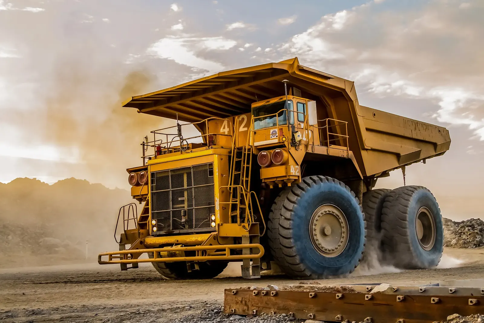
The Teltonika solution for mining companies: an FMC650 tracker on ore haulers and lorries reports coordinates, load weight and fuel consumption, and where there is no cellular network it switches to a satellite link.
The Teltonika solution for mining companies: an FMC650 tracker on ore haulers and lorries reports coordinates, load weight and fuel consumption, and where there is no cellular network it switches to a satellite link. Quarries and mines are usually a long way from towns, and the journey from the extraction site to the processing plant, the port or the buyer can run to hundreds of kilometres. Along the way the lorry often ends up out of mobile coverage, while the cargo is valuable and easily grows lighter en route. In this use case a single professional tracker covers several jobs at once: following the vehicle, monitoring weight, geofences, driver identification, a panic button and fuel records.
What this scenario solves
On remote extraction sites there is no 2G, no 3G and no 4G, and the vehicle disappears from the map.
Part of the load can go missing on the way, and without weight data nobody will notice.
The dispatcher cannot see where loaded vehicles are standing idle or why there are fewer runs than planned.
An ordinary tracker with internal antennas picks up a poor signal inside the metal cab of heavy equipment.
On remote extraction sites there is no 2G, no 3G and no 4G, and the vehicle disappears from the map.
Part of the load can go missing on the way, and without weight data nobody will notice.
The dispatcher cannot see where loaded vehicles are standing idle or why there are fewer runs than planned.
An ordinary tracker with internal antennas picks up a poor signal inside the metal cab of heavy equipment.
Mining is not only excavators in a pit but also a great deal of logistics. Heavy equipment, spare parts and fuel have to be brought in, and ore, concentrate or stone taken out. Quarries stand in remote districts, and the roads from them run across steppe, mountains or desert.
The sorest point is communications. On many such routes there is not a single cellular network. A tracker that works only over GSM goes silent for that whole time, and the dispatcher sees the vehicle only when it comes out near the nearest mast. What happened during those hours is unknown.
The second point is the cargo itself. A large number of vehicles leaves a quarry all the time, and if the weight is not measured on departure and on arrival, a shortfall is discovered late or not at all. Part of a load can be siphoned off along the way, and the difference gets written off as measurement error.
The third point is run time. Every extra hour a loaded vehicle stands still is one run lost. To hit the plan you need to see where vehicles are standing, how long loading and unloading take, which drivers do more runs and why.
And finally the hardware. The bodies of tippers and tractor units are solid metal. A tracker with internal antennas, hidden under the dashboard, loses both the satellites and the network in a cab like that.
What Teltonika offers
An ore hauler is fitted with an FMC650 with external antennas: it sends coordinates, load weight and fuel data over the cellular network, and when there is no network, through a satellite modem connected over RS232.
Installation and setup
Fitting the device and configuring it for the fleet scenario at hand.
Data transfer
The device collects data and sends it to the monitoring platform; how often depends on the model and its settings.
Analysis and control
The person in charge gets reports and alerts and looks into what stands out.
High-gain external GNSS and GSM antennas are brought out onto the cab roof or another open spot. That solves the problem of the metal body: the tracker sees satellites reliably and holds its link even in heavy equipment.
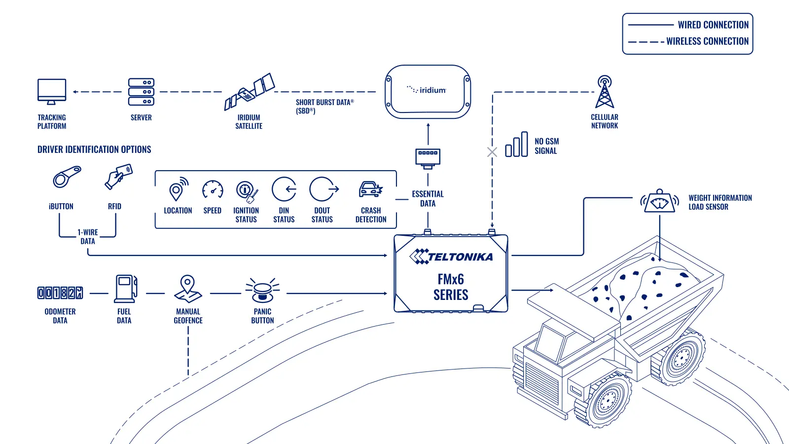
Communications on two levels. While the vehicle is in coverage the data go over the mobile network, and Dual-SIM lets it hold two SIMs from different operators and switch to whichever has the better signal. When both networks drop out, the FMC650 sends data through the satellite modem. A satellite link covers practically the entire surface of the Earth, so the dispatcher does not lose the vehicle in a desert or in the mountains. Over satellite it is usually only the essentials that are sent — coordinates, alerts, key events — because traffic there costs more.
Load weight. Axle or suspension load sensors are connected to the tracker. The system knows how much the vehicle took on at loading and sees it if the weight drops en route. If someone tries to take part of the load off, the operator receives an event with the weight difference and the coordinates of the place where it happened.
Geofences. Permitted routes and zones are drawn on the map: the quarry, the road, the unloading point. The vehicle is supposed to work inside those boundaries. If it turns off or enters a restricted zone, the dispatcher is notified immediately.
The driver. Identification through iButton or RFID over 1-Wire means only someone cleared to operate the vehicle can start it, and it ties every run to a particular person. In case of danger a panic button is fitted in the cab: the driver presses it and the dispatcher sees the signal with exact coordinates.
Fuel. The FMC650 reads data off the lorry's bus: FMS CAN to SAE J1939 and fuel data over J1708. Where there is no bus, or its data cannot be trusted, a fuel level sensor is fitted. The level and the consumption are visible for each vehicle, and drains are flagged as separate events.
Bluetooth on top. The tracker works with wireless sensors: beacons, temperature and humidity sensors, magnetic sensors and movement sensors. That is useful, for instance, for monitoring the opening of a body or keeping track of a trailer.
What this looks like on a run. A tipper has loaded at the quarry, the sensors showed 32 tonnes, and the vehicle has left the quarry geofence. Forty kilometres on it goes out of cellular coverage and the tracker switches to satellite: a point arrives every few minutes and there are no alerts. Halfway along the route the vehicle stops for 25 minutes at a place where the schedule has no stop, and after the stop the weight drops by one and a half tonnes. The dispatcher receives an event with coordinates before the lorry is even back in coverage. When the network appears, the tracker sends up the full track from memory, and it is clear that another vehicle was standing at the stopping point. The conversation with the driver then runs on facts, not on explanations about the load spilling out.
In practice the basic setup is configured first: coordinates, geofences, driver, panic button. Weight and fuel are connected in a second stage, once the sensors are calibrated and it is clear what margin of error a particular vehicle has. Otherwise the dispatcher drowns in false alerts for the first few weeks.
Site survey and acceptance. Before fitting, the route from the quarry to the unloading point is driven, noting where Azercell, Bakcell and Nar hold a signal, where Dual-SIM will be enough and where the vehicle will disappear without a satellite link. On each model of tipper a position for the external antennas is chosen out of the bucket's reach, and the suspension type is established: which load sensor will suit depends on it. Acceptance is done on the real machines: a control weighing of the vehicle empty and loaded on the quarry weighbridge is compared with the sensor readings, while the "loading — departure — unloading" cycle over several shifts is checked against the dispatcher's log.
The upshot is that the dispatcher sees on one screen a map of every vehicle, its weight, its fuel, its driver and its events. After the shift they get a report on the runs: how much was hauled, where vehicles stood idle, whose weight did not add up.
What you get
The vehicle does not disappear from the map
With no cellular network the data go over a satellite link, and Dual-SIM picks the better operator where there is a network.
A shortfall is visible en route
Load sensors show the weight at loading and raise a signal if it has changed along the way.
The route under control
Geofences flag any deviation from the permitted road and any entry into restricted zones.
Only cleared drivers at the wheel
IButton or RFID stops an outsider starting the vehicle and ties every run to a driver.
Help at the press of a button
An alert with coordinates reaches the dispatcher even from a stretch with no mobile coverage.
More runs per shift
Reports on stops, loading and unloading show where the time is going.
Why this solution
The FMC650 was chosen because one device replaces several. External antennas, Dual-SIM, RS232 for a satellite modem, FMS and J1708, 1-Wire for identification, analogue inputs for weight and fuel sensors, Bluetooth for wireless sensors. For mining equipment, where every extra device is one more point of failure, that matters.
The tracker is built for commercial vehicles: it runs off 12 and 24 V electrical systems, stands up to vibration and swings in temperature, and holds data in memory while there is neither cellular nor satellite coverage.
And one more practical thing: settings and firmware are changed remotely. There is no need to send a technician out to a quarry half a day's drive away just to change the data transmission interval.
How this works in Azerbaijan. Similar problems face the crushed stone and sand quarries in the Garadagh district and on Absheron, building stone extraction in Gakh and Shamkir, the mining projects in Dashkesan and Gadabay, and haulage out of the liberated districts of Karabakh and Kalbajar, where deposits are being explored. On the mountain roads out of Kalbajar and Lachin mobile coverage drops out in places, and that is where a satellite link earns its place. What to allow for when rolling out: load sensors have to be calibrated on every vehicle, older KamAZ and MAZ lorries have no FMS and consumption there is worked out from an Escort fuel level sensor alone, and antennas on tippers are routed so that they are not knocked off during loading. GPS.az fits the FMC650 to quarry and haulage vehicles, connects weight sensors, fuel level sensors and panic buttons and sets up run reports on the Wialon platform.
Related case studies
Related rollouts and equipment
Questions about the “Ore haulage control: load weight and satellite” scenario
Request a call
A specialist will call back and match a solution to your fleet and your task.