
GPS tracking of rally crews
A Teltonika scenario for rally and Baja organisers: a rugged FMB204 tracker on every vehicle shows race control where a crew is, how fast it is going and whether it has had an accident.
A Teltonika scenario for rally and Baja organisers: a rugged FMB204 tracker on every vehicle shows race control where a crew is, how fast it is going and whether it has had an accident. At a rally the spectators see dust, gravel and cars flying off jumps. Race control sees something else: fifty vehicles strung out over tens of kilometres of rough ground, the checkpoints, the speed-restricted sections, and the medics who have to be sent to wherever something has gone wrong. Without telemetry that control room works blind, on radio traffic and phone calls.
What this scenario solves
Point-to-point races spread the competitors over a large area, and the organiser cannot see them with his own eyes.
At any moment race control has to know where each vehicle is and whether its engine is running.
An accident on a remote special stage can go unnoticed until the next crew reaches the spot.
A rally field is very mixed: cars, motorcycles, lorries, SxS and UTV buggies, ATV quad bikes, and in some disciplines karts, boats and snowmobiles.
Point-to-point races spread the competitors over a large area, and the organiser cannot see them with his own eyes. At any moment race control has to know where each vehicle is and whether its engine is running. An accident on a remote special stage can go unnoticed until the next crew reaches the spot.
A rally field is very mixed: cars, motorcycles, lorries, SxS and UTV buggies, ATV quad bikes, and in some disciplines karts, boats and snowmobiles. One device has to fit any of them and survive water, mud, stones and impacts.
The market is growing: ResearchAndMarkets.com puts global motorsport at 4.8 billion dollars in 2020, with a possible 7.8 billion by 2027. More competitors and more spectators mean more accidents, more safety requirements and more work for organisers.
Results depend on data too. A missed checkpoint, speeding on a restricted section, penalty minutes — all of it has to be counted precisely, or an argument with a team is inevitable.
What Teltonika offers
For rallying Teltonika offers the FMB204 tracker: a compact IP67-rated housing, high-gain internal GNSS and GSM antennas and a lithium-ion battery of increased capacity let it be fitted to any vehicle with no fear of a water crossing, of dust, or of a loss of power mid-stage.
Installation and setup
Fitting the device and configuring it for the fleet scenario at hand.
Data transfer
The device collects data and sends it to the monitoring platform; how often depends on the model and its settings.
Analysis and control
The person in charge gets reports and alerts and looks into what stands out.
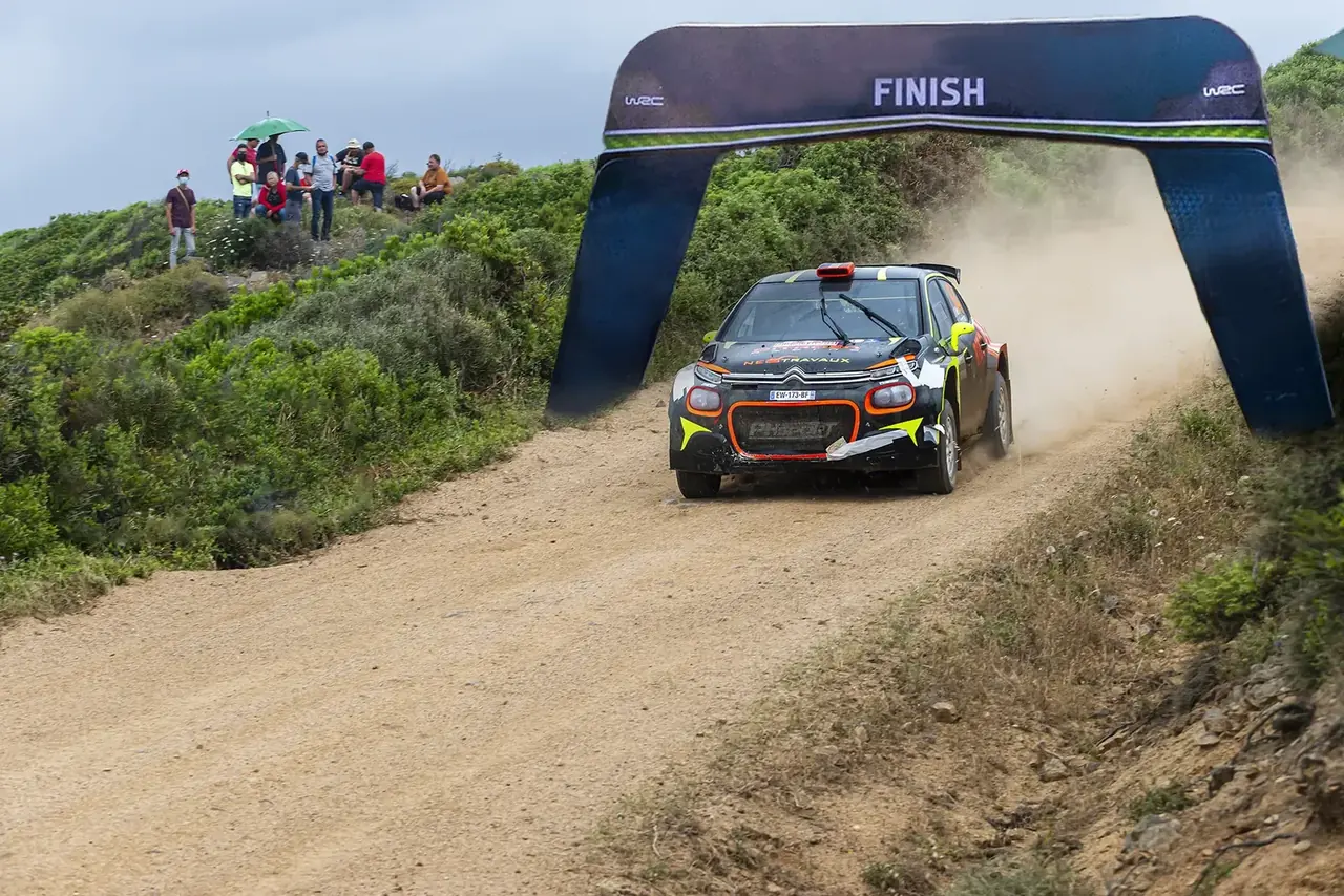
The FMB204 has no external antennas, so there is nothing for a branch to tear off or a stone to smash. The housing copes with tarmac, gravel, sand, mud, water, potholes and blows from undergrowth. If a crash tears the power lead out, the tracker keeps running on its own battery and keeps sending coordinates — exactly when they are needed most.
How it is organised. Before the start the organiser fits trackers to all the vehicles, configures them and checks them: each must appear on the control room map with the right crew number. Scrutineering before the race is a good moment to confirm that a device sees the satellites and gets on air. Better to do it under open sky than inside a covered garage.
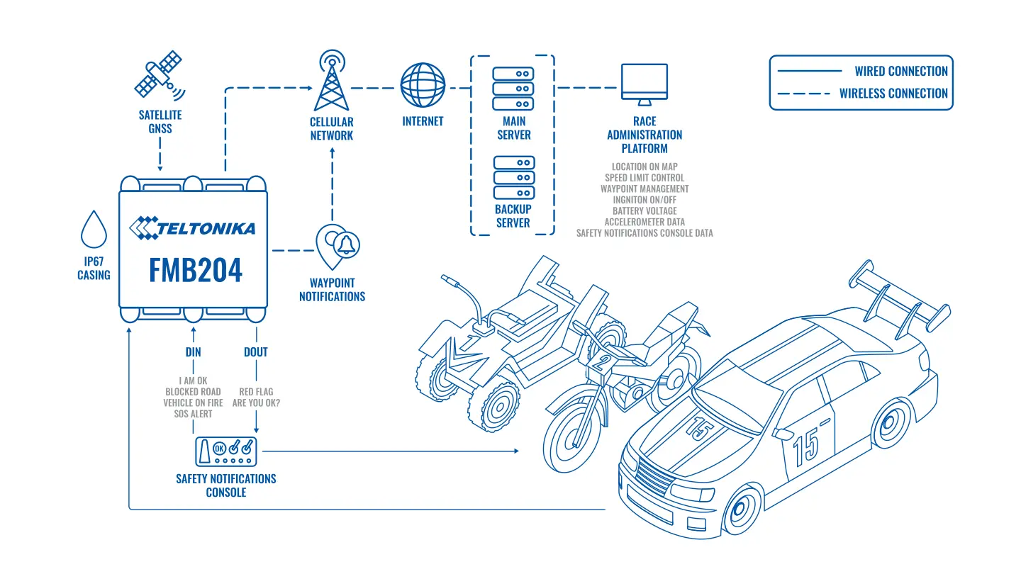
During a stage the FMB204 transmits coordinates, speed, supply voltage, data from its built-in accelerometer, and ignition on and off. Events are derived from the same data: speeding, a long stop, a crash. The data goes over the mobile network to the primary and the backup server at once, so one server going down does not leave race control without a picture. Where a section has no coverage, the points build up in internal flash memory and are sent on as soon as the network reappears.
From there the race management software takes over. Race control sees every competitor on the map, hold-ups on the route and departures from it. The system records which checkpoints a crew has passed and which it has missed, and sends a notification. On sections where the organiser has imposed a speed limit — passing through a village or a service park, for example — speeding is logged automatically and turns into penalty points or minutes.
Picture a special stage in semi-desert. Crew No. 27 has stopped moving, the accelerometer registered a heavy impact, and the ignition is off. Race control sees this within seconds rather than when the next car radios in about a rolled buggy. The nearest medical vehicle is sent to exact coordinates. If the crew has simply broken down and is unhurt, recovery is sent out instead and the following competitors are warned of an obstruction.
Specialist third-party software can use the same data to put safety messages on displays in the cockpit: yellow flag ahead, race stopped, slow down on a dangerous section. The crew gets the information even when the radio is silent.
Tracker configuration and firmware are updated remotely through FOTA WEB. For an organiser with a hundred devices in store and in vehicles between rounds, that saves days of work.
How to prepare the trackers so there are no surprises. Mount the device rigidly, with cable ties or on a bracket, rather than on double-sided tape: over rough ground anything held on by adhesive has fallen off by the middle of the stage. Choose a spot with open sky above the housing, otherwise the internal GNSS antenna will struggle to hold satellites under a metal roof. Charge the battery the day before, and take the feed from the vehicle's electrics through a fuse. At scrutineering each tracker is checked against a list: crew number in the system, a fresh point on the map, and the response to the ignition being switched on.
After the finish the trackers are removed, charged and stored until the next round. If the organiser runs a series over a season, the same devices move from vehicle to vehicle, and the record of which tracker is on which crew is kept in the monitoring system itself rather than on a paper sheet.
What you get
Every crew on the map at any moment
Race control sees positions, hold-ups and departures from the route without waiting for radio calls.
Help goes to the right place
A crash or a stopped vehicle arrives as a notification with coordinates, and the medics are dispatched at once.
Fair scoring
Checkpoints passed and missed, and speeding on restricted sections, are logged automatically.
Extra services for teams and spectators
Tracks in GPX format, event maps and live broadcasting of competitors' positions.
Less trouble for the organiser
Fewer people on manual checks, fewer disputes with teams, and more confidence from competitors and sponsors.
Why this solution
The FMB204 was made to work where an ordinary tracker in a plastic case would not survive. IP67, internal antennas and its own battery are exactly what a vehicle crossing rivers and landing off jumps needs. One model fits a buggy, a motorcycle and a support lorry alike, so the organiser does not have to keep a menagerie of devices.
The data goes to two servers at once, and that is no small thing for a race where losing the picture in the control room means stopping the stage. FOTA WEB allows the whole pool of trackers to be reconfigured between rounds: transmission rate, accelerometer thresholds, server addresses.
The limitations are worth knowing in advance. The tracker sends its data over the mobile network, and in remote places with no coverage race control will see the points late, once the vehicle reaches a signal. For desert and mountain events organisers write that into the regulations: they set up repeaters, choose the route with coverage in mind, or add a satellite link on key vehicles. The transmission rate affects the picture too: for rallying it is set far higher than for ordinary commercial vehicles, and data usage rises for the duration of the event.
The data does not disappear after the race. Each crew's track can be gone through minute by minute: where time was lost, where a corner was cut, where the car stood still. Teams need that to prepare for the next round, the organiser to deal with protests. When a team insists it passed a checkpoint and the marshal did not record it, a time-stamped track settles the question in a minute.
How this works in Azerbaijan. This kind of monitoring suits off-road competitions and cross-country rallies run on the gravel roads of Gobustan, Absheron and the foothills of the Greater Caucasus, club events on quad bikes and buggies, and also quad bike hire for tourists in mountain districts such as Guba, Gabala and Sheki, where the owner wants to see where a customer has taken the machine. What we allow for when fitting: dust and heat in summer, so the tracker goes in an enclosed spot well away from the exhaust; in the mountains and gorges Azercell, Bakcell and Nar coverage drops out, so we check the route in advance and configure the point buffer; for the duration of the event we raise the transmission rate and afterwards return to an economical mode. GPS.az fits the FMB204 to the vehicles, sets the crews up in Wialon, draws geofences for checkpoints and speed-restricted sections, and configures crash and stop notifications for race control.
How monitoring differs from timing. The tracker sends points at a set interval and with the latency of a mobile network, and GNSS coordinates carry an error of several metres, so it does not replace the official timing system or the marshals' records. Its role is safety and route control: where the crew is, whether it has stopped, whether it has passed through a checkpoint zone. In dealing with a protest the track serves as supporting material, and how it is to be treated is best written into the event regulations in advance.
Related case studies
Related rollouts and equipment
Questions about the “GPS tracking of rally crews” scenario
Request a call
A specialist will call back and match a solution to your fleet and your task.