
Vehicle monitoring where there is no cellular coverage
A Teltonika solution for logistics in remote areas: the FMC650 tracker works over the cellular network, and where there is none it switches to a satellite modem and sends short packets.
A Teltonika solution for logistics in remote areas: the FMC650 tracker works over the cellular network, and where there is none it switches to a satellite modem and sends short packets. The routes of many hauliers pass through places where a phone shows no service: mountains, deserts, steppe, border districts. An ordinary tracker there simply accumulates positions in memory, and for hours the dispatcher has no idea what is happening to the vehicle or the driver. Teltonika proposes a pairing of a PROFESSIONAL series tracker with a satellite modem. The key to this solution is not the satellite itself but the way transmission is arranged: the satellite channel is used only when it is needed, and the packet carries only the most important things, so that connectivity does not cost a fortune.
What this scenario solves
On the margins, in the mountains and across large empty territories there is often no cellular coverage at all, or it works only in snatches.
As operators move to 4G and 5G, old 2G masts in remote areas are frequently taken out of service, and the holes in coverage multiply.
A vehicle with no connectivity in a border district becomes an easy target for robbers, and the driver cannot call for help after an accident.
Satellite data transmission is expensive, and sending everything over it makes no economic sense.
On the margins, in the mountains and across large empty territories there is often no cellular coverage at all, or it works only in snatches. As operators move to 4G and 5G, old 2G masts in remote areas are frequently taken out of service, and the holes in coverage multiply. A vehicle with no connectivity in a border district becomes an easy target for robbers, and the driver cannot call for help after an accident. Satellite data transmission is expensive, and sending everything over it makes no economic sense.
There are many such places on the world map: African deserts, Australian plains, South American jungle. But developed countries too have plenty of roads where coverage disappears for tens of kilometres because of the terrain — hills and mountains simply block the signal.
For a logistics manager this is a blind spot. The vehicle has set off on its run, and after that all you can do is wait for it to reappear on the network. If something has happened in the meantime — theft, an accident, a breakdown, the driver falling ill — it is learned about late, sometimes critically late.
The obvious answer is to fit a satellite link. But satellite traffic costs many times more than cellular. If you send the same data over it as over a mobile network, the communications bill will quickly outweigh the benefit. So two questions have to be settled at once: when to switch the satellite on, and exactly what to send over it so that the manager still understands what is happening to the vehicle.
What Teltonika offers
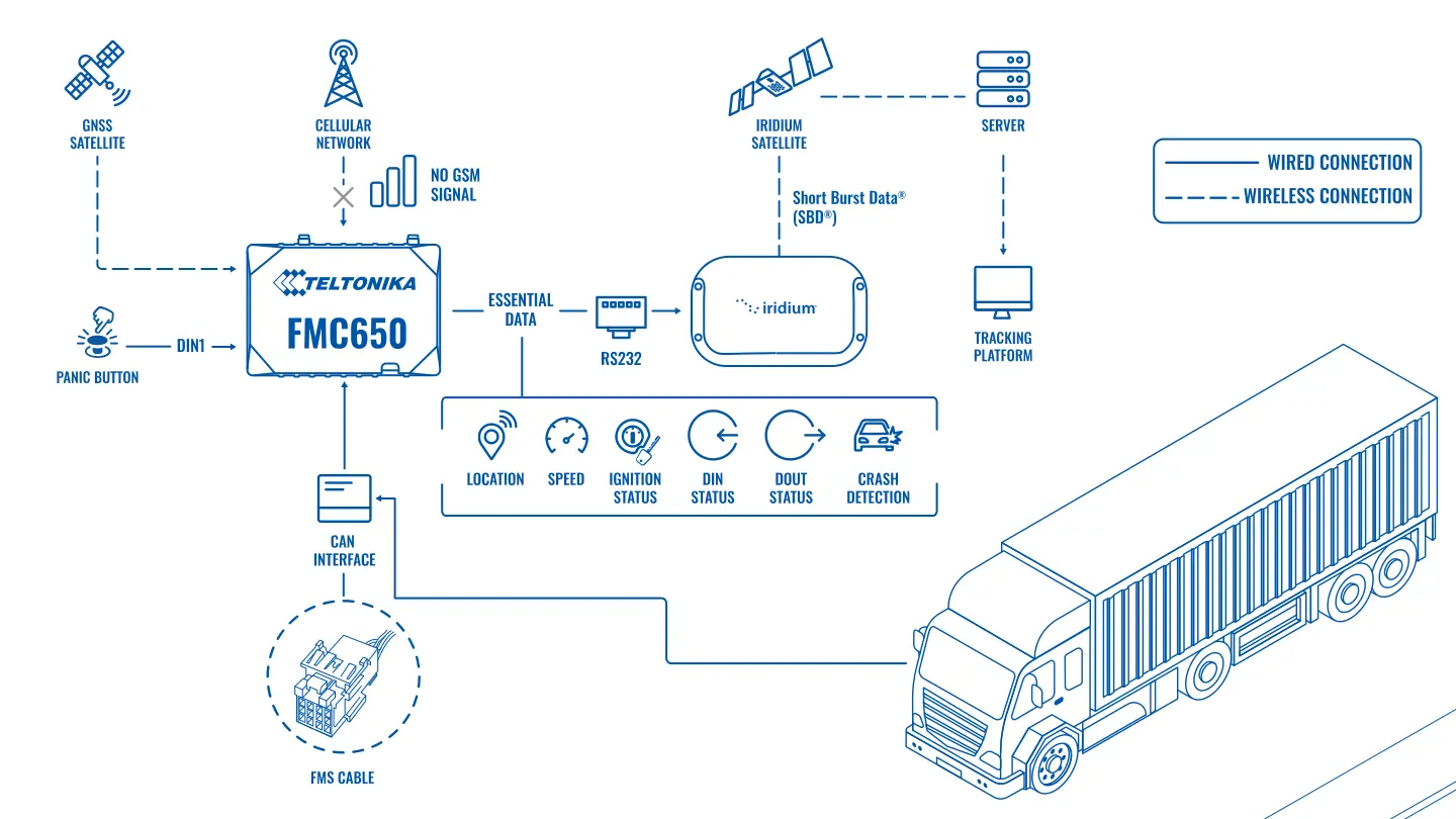
An FMC650 tracker with a cellular modem is connected to an external satellite modem: inside the coverage area the data goes over the mobile network, and outside it the tracker sends a short packet with the essentials over satellite.
Installation and setup
Fitting the device and configuring it for the fleet scenario at hand.
Data transfer
The device collects data and sends it to the monitoring platform; how often depends on the model and its settings.
Analysis and control
The person in charge gets reports and alerts and looks into what stands out.
For this use case Teltonika took the FMC650 from the PROFESSIONAL range (the FMx6 series). It is built for harsh conditions, receives GNSS signals, works on cellular networks and can make selective use of a satellite channel through an external modem. Two RS232 ports allow other equipment to be connected in parallel — temperature and fuel level sensors and whatever else a particular haulier needs.
What the tracker does in normal mode. The FMC650 is fitted to lorries, tractor units and other machinery and transmits coordinates, fuel consumption data and driver behaviour. Driver identification, aggressive driving monitoring and detection of tampering and unauthorised access all work. While there is cellular coverage, all of it goes to the server as usual.
When there is no network. The tracker recognises that the cellular channel is unavailable and switches to the satellite modem. What goes over satellite is not the full data set but a minimal packet: coordinates, speed and the state of the digital inputs and outputs. That is enough to see the vehicle on the map and to know whether everything is in order.
The trick lies in the digital outputs. The FMC650 has four of them, and each can be tied to a specific event. For instance, one output reflects the body door sensor, a second the driver's panic button, a third the trailer door sensor, and the fourth the ignition. The state of an output takes up a single bit in the packet, and the manager sees immediately why the message arrived: the trailer was opened out on the steppe, or the driver pressed the panic button.
Outputs can also be switched by the built-in functions: speeding, signal jamming, aggressive driving. Plus the customer's own scenarios. Rather than pushing a voltage or analogue input value over satellite, the tracker compares it with a threshold itself and changes the state of an output. One bit goes over satellite instead of a number, and the cost of the link stays low.
If the standard set is not enough, Teltonika can make a modification for a project. One example is transmitting the direction of impact over the satellite channel when the crash detection function triggers.
What the dispatcher sees. Inside cellular coverage, the usual detailed picture. In a blind spot, infrequent but regular positions with speed and event statuses. If a packet arrives with a panic button signal or an open door, the dispatcher reacts at once rather than waiting for the vehicle to come back on the network.
An example. A tractor unit is travelling a mountain road and the network has been gone for two hours. Previously the dispatcher would simply have seen the vehicle frozen in place. Now a short packet with a position arrives every few minutes. On one of them the trailer door bit changes value, even though the ignition is off and the vehicle is stationary. That is grounds for contacting the driver immediately and, if necessary, the police in the nearest district.
How the channels divide the work. The cellular channel remains the main one: full data at the set interval, sensors and reports all travel over it. The satellite channel is enabled by a condition set in the configuration: for example, if the tracker has been unable to send data over the mobile network for a set time. Only a short packet goes over satellite. When the network returns, the tracker works over cellular again and uploads the detailed history it has accumulated, so that the route is reconstructed in full in the reports, simply with a delay.
Interval and tariff. The frequency of satellite messages and the set of events sent immediately are chosen before launch, because the satellite bill is calculated from the number and size of messages. The tariff and terms are agreed separately with the satellite communications provider and depend on the modem chosen.
If both channels are lost. Under a canopy, in a shed, deep in a gorge or with the antenna obstructed, a satellite packet may also fail to get out. The tracker accumulates data in memory, and a rule is set on the platform: if a vehicle has been silent for longer than a set time, the dispatcher receives a notification and follows the procedure — a call to the driver, a check of the last position, contact with the nearest base.
What you get
The vehicle is visible outside cellular coverage
The satellite modem sends short packets where there is no mobile network, provided the antenna has a clear view of the sky.
The satellite is used only when needed
While the mobile network is available the data goes over it, and the expensive channel works as a fallback.
The essentials in a single packet
Coordinates, speed and event statuses packed into the bits of digital outputs keep the communications bill under control.
Alerts get through even from the back of beyond
The panic button, a trailer door being forced and signal jamming are transmitted over satellite immediately, not after the vehicle returns to the network.
Sensors connect over RS232
Two ports allow fuel and temperature monitoring and other equipment to be added without changing the tracker.
Modification for a project
If particular data has to travel over satellite, Teltonika can extend the firmware to suit the customer's task.
Why this solution
The FMC650 was chosen because it has everything needed for this arrangement. Four digital outputs mean four events that can be transmitted almost free of charge. Two RS232 ports leave room for both the satellite modem and the sensors. Flexible scenario logic makes it possible to decide on the tracker itself what matters and what does not, before the data goes into the expensive channel.
A PROFESSIONAL series tracker is built for long service in heavy vehicles: vibration, temperature swings, dust. For vehicles that spend months on poor roads that matters more than a list of functions on paper.
Another reason is the carefully thought-out economics. Teltonika does not propose replacing cellular with satellite; it makes satellite a fallback with minimal traffic. That is usually exactly what a haulier needs: to see the vehicle along the whole route, but to pay for satellite only when there is no alternative.
An honest limitation: the satellite channel will not let you watch detailed tracks, video or fuel graphs in real time. The tracker keeps the detailed data in memory and uploads it when the vehicle is back in cellular coverage.
What to decide before fitting. First, the interval for satellite messages: every 5 minutes, every 15, or only on events. The communications bill depends directly on this. Second, which four events deserve a bit of their own in the packet. For a refrigerated trailer that might be temperature going outside its limits; for a carrier of valuable goods, the trailer door and the panic button; for machinery on a construction site, working outside the permitted zone or the engine being started at night. Third, where to put the satellite modem antenna: it needs a clear view of the sky, so it goes on the cab roof rather than being hidden behind metal panels.
And one more practical piece of advice: the satellite channel is worth testing on a trial run through a real blind spot before equipping the whole fleet. That shows at once whether the traffic fits the expected budget, whether the positions are too infrequent for the dispatcher, and whether the events on the digital outputs trigger correctly.
How this works in Azerbaijan. Cellular coverage on the main M-1, M-2, M-3 and M-4 highways is generally good, but blind spots exist: the mountain roads of the Guba-Gusar region, the passes to Shahdag and Lahij, parts of Nakhchivan, and remote areas in Karabakh and East Zangezur where reconstruction work is under way. Tipper lorries, concrete mixers and road contractors' machinery work there, and losing sight of them for half a day is a common story. For hauliers running beyond the country's borders through Georgia, Turkey or Iran, or along the Middle Corridor across the Caspian, the satellite channel covers the stretches where the local network is unavailable or roaming is too expensive. For Azerbaijan, satellite communications are arranged as a separate project: we select the particular modem and tariff to suit the routes. In winter coverage on the passes drops out more often, and that is exactly when seeing the vehicle and receiving an alert from the driver matters most. GPS.az fits the FMC650, connects the satellite modem and the sensors, configures the output logic and, on the Wialon platform, brings both cellular and satellite data onto one map and into one set of reports.
Related case studies
Related rollouts and equipment
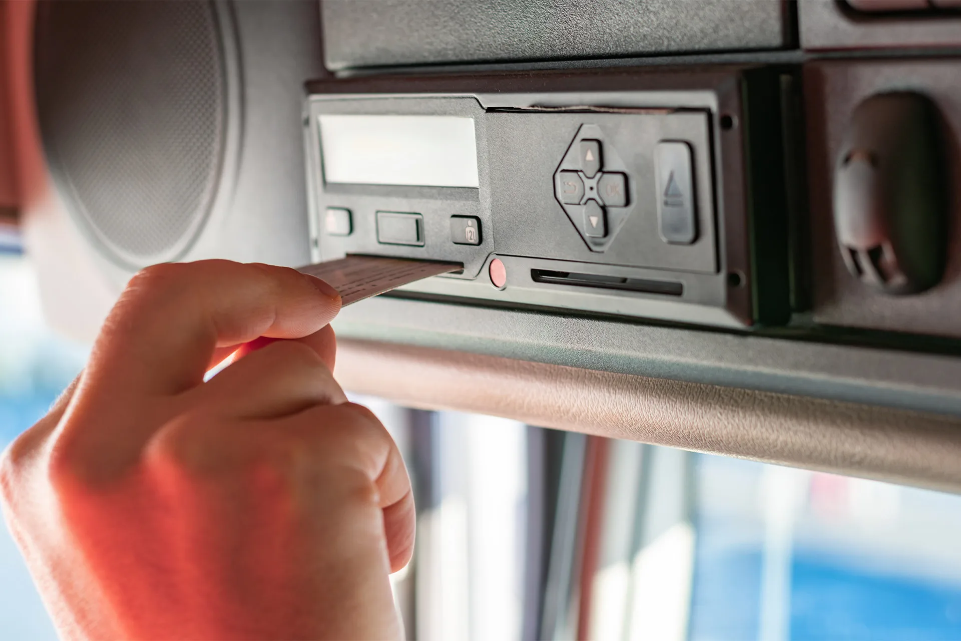
Remote tachograph downloads through the FMC650
Logistics and delivery
Keeping track of trailers with EYE Bluetooth beacons
Logistics and delivery
Cold chain: temperature recorder plus FMC650 tracker
Logistics and delivery
Questions about the “Vehicle monitoring where there is no cellular coverage” scenario
Request a call
A specialist will call back and match a solution to your fleet and your task.