
Geofences under movement restrictions
A Teltonika scenario from the COVID-19 period: an FMM130 tracker with geofences reports when a vehicle leaves the permitted radius or enters a closed district.
A Teltonika scenario from the COVID-19 period: an FMM130 tracker with geofences reports when a vehicle leaves the permitted radius or enters a closed district. A geofence is an area on the map defined by a circle, a rectangle or a distance from a point. When a vehicle carrying a tracker crosses its boundary, the system records the event and can warn the driver or the owner immediately. The function is present in every Teltonika GPS tracker, and it is used for far more than epidemics. In 2020, movement restrictions turned geofences into a tool that was useful to families and companies alike: anyone getting behind the wheel needed to know where the edge of the permitted area ran.
What this scenario solves
During lockdown the rules on movement changed from week to week.
The permitted area was often defined as a radius from home, and an odometer does not show that radius.
Closed districts sat next to open ones, and a driver could easily stray into one by mistake.
Companies had to know that their vehicles and staff were not going beyond the permitted limits.
During lockdown the rules on movement changed from week to week. The permitted area was often defined as a radius from home, and an odometer does not show that radius. Closed districts sat next to open ones, and a driver could easily stray into one by mistake. Companies had to know that their vehicles and staff were not going beyond the permitted limits.
The scale was enormous. The World Health Organization declared COVID-19 a pandemic, with cases recorded in more than 150 countries. By the middle of May 2020 more than 4 million infections and more than 300,000 deaths had been confirmed worldwide. Governments were trying to ease restrictions to save their economies while at the same time keeping a second wave at bay.
The French example. After the first lockdown, trips of up to 100 km from home were allowed there without any need to give a reason. Beyond that, only for work or serious family reasons, and with written confirmation. An important detail: the distance counted is the straight line from home, not the kilometres the vehicle has driven. Forty minutes on hairpin bends may be only 30 km from home, while a straight motorway takes you past the limit in no time.
The Chilean example. Lockdown was introduced in parts of Santiago and a curfew across the whole country. A full lockdown applied in Greater Santiago, in a number of communes in other regions, and in Arica, Iquique and Alto Hospicio. The map became a mosaic of districts that could not be entered and districts with a high risk. Keeping all of that in mind while driving is impossible.
Which raises a simple question: how do you tell, while you are driving, that you are still inside the permitted area, without guessing and without eyeballing the satnav?
What Teltonika offers
The FMM130 tracker checks the vehicle's position by satellite and, as soon as it crosses a defined boundary, sends an event and triggers an alert — audible, visual, SMS, email or push.
Installation and setup
Fitting the device and configuring it for the fleet scenario at hand.
Data transfer
The device collects data and sends it to the monitoring platform; how often depends on the model and its settings.
Analysis and control
The person in charge gets reports and alerts and looks into what stands out.
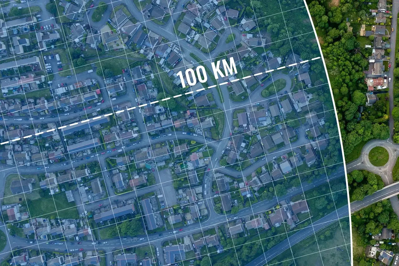
What a geofence is in a monitoring system. It is a virtual boundary drawn on the map in the vehicle monitoring software. The shape is a circle or a rectangle, and the platform also accepts an arbitrary polygon. For each zone you choose when an event should be generated: on entry, on exit or both. A maximum speed inside the zone can be set as well.
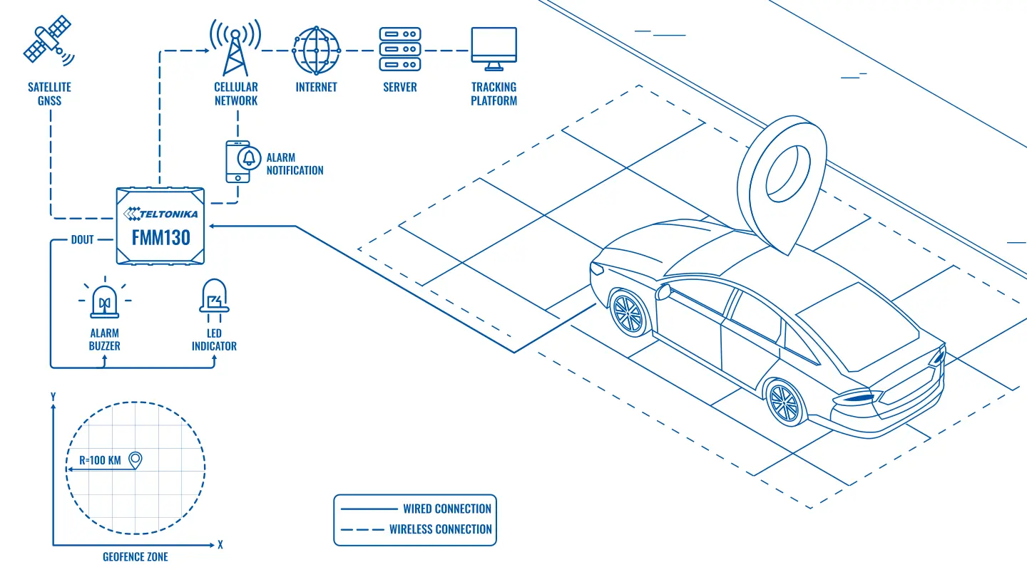
How the alert fires. The tracker continuously establishes its position by GNSS and compares it with the zone boundaries. On a crossing it switches the DOUT digital output, to which a buzzer or an LED in the cabin is connected, and at the same time sends the event to the server. From there the vehicle owner, the fleet manager or whoever else is responsible receives an SMS, an email or a push notification on a smartphone.
For a radius restriction. A circular geofence with a radius of, say, 100 km is centred on the home address. The driver hears a signal as he approaches the boundary, and the owner sees the crossing in the history. There is no need to work out the straight-line distance by hand.
For closed districts. Each district under lockdown becomes a separate zone with an entry event. The driver learns about the mistake straight away rather than when a patrol stops him.
For a family. A zone around the house shows when the family car left and when it came back. A zone around a school or a child's workplace shows that he arrived on time and was home before the curfew. If the car suddenly leaves the zone around the house at night, that is a reason to check at once whether someone is trying to steal it. There is a domestic version too: a zone around a favourite shop means that while a member of the family is there, you can send additions to the shopping list rather than making a second trip.
For a company. Geofences around warehouses, customer sites and offices give timestamps for arrival and departure. Zones around districts that staff may not enter record the breaches. The event log shows who arrived at a site, when, and how long they spent there — which is useful well beyond a pandemic.
What it looks like in real life. A company's service engineer drives to a customer in the next town. His route runs alongside a district that is closed to traffic. The satnav routes him through that district because it is shorter. As he enters the zone the buzzer sounds in the cabin, the driver turns round and takes the long way, and the manager sees a short entry and exit event in the log with a timestamp. The conversation after the trip takes a minute: the reason is clear, and in substance there was no breach.
If the rules change. Zones are edited in the platform in a few minutes: widen the radius, add a newly closed district, remove an old one. Server-side notifications need no reconfiguration of the tracker; if a signal in the cabin is required, the new zones are loaded into the device remotely.
Why the FMM130. It is a new-generation tracker with LTE Cat M1 and NB-IoT and 2G as a fallback, with digital inputs and outputs for a buzzer, an LED or an immobiliser. The geofence logic runs inside the device, so the audible signal in the cabin fires even when the connection is weak, and the event reaches the server once the network returns.
What to bear in mind. Restrictions are set by the authorities; the tracker only helps you comply with them and does not replace official permits. If several different people drive the vehicle, it is worth agreeing who receives the alerts, so that oversight does not turn into surveillance. For company vehicles, staff must be told about the monitoring in advance.
The business case today. The pandemic restrictions are gone, and in this form the scenario is no longer needed. The same mechanics now handle everyday tasks: arrival times at sites, permitted working districts, speed limits inside zones, and keeping track of company vehicles leaving the region.
The basis on which data is collected. For company vehicles, staff are told about the monitoring in advance, and the purpose and access to the data are set out in an internal policy. In a family's private car, the rules are agreed between family members.
When the scenario ends. Temporary zones are created with a clear condition for removal: the end of a restriction, the completion of a site, the end of a season. Once the condition is met, the zones and notifications are deleted so that they do not generate pointless events.
What you get
A clear edge to the permitted area
Driver and owner learn about leaving the radius or entering a closed district straight away, not from a fine.
Protection against theft
A vehicle leaving the zone around the house at an odd hour is visible at once and can be reacted to quickly.
Fleet coordination
Entry and exit marks at warehouses and sites show where each vehicle is and how long it stands there.
Driver discipline
Trips into prohibited districts and speeding inside a zone are recorded automatically.
For families and for businesses
The same tracker suits a private car and a corporate fleet, and alerts arrive on a smartphone, a tablet or a computer.
Lawful oversight of company vehicles
A company is entitled to track its own vehicles as long as the data is used only in its working interests.
Why this solution
Geofences are in the firmware of every Teltonika GPS tracker, from the simple FMB models to the professional FMC and FMM and the personal FT range. There is no need to pick a special device for this job — it is enough to configure properly what is already in the vehicle.
Teltonika has shipped more than 17 million devices, working in over 160 countries. The trackers are designed for cars, off-roaders, light commercial vehicles, lorries, buses, municipal, construction and quarry plant, taxis and motorcycles.
The FMM130 suits this scenario because it combines modern LTE Cat M1 and NB-IoT connectivity with a set of inputs and outputs: a buzzer or an indicator in the cabin is easy to wire to it, so the driver hears the boundary signal without a smartphone.
How this works in Azerbaijan. In 2020 the country also had a special quarantine regime with restrictions on movement, and the question of where you were allowed to drive was just as pressing. Today geofences are used more often in ordinary work: zones around the sites of oil and gas contractors in Absheron, construction sites in Karabakh, warehouses in Baku and the terminals of the port of Alat, and service area boundaries for distributors in Ganja, Sheki and Lankaran. For hauliers on the M-1, M-2 and M-3, zones at the border crossings are useful for seeing when a vehicle reached the border. In the mountain districts beyond Guba and Gusar the connection can be weak, but the geofence logic runs inside the tracker itself and the data arrives later. GPS.az fits Teltonika trackers, draws the geofences and sets up entry, exit and speeding alerts in the Wialon platform to suit the needs of your family or your company.
Related case studies
Related rollouts and equipment

Questions about the “Geofences under movement restrictions” scenario
Request a call
A specialist will call back and match a solution to your fleet and your task.