
Monitoring airport ground support equipment
Teltonika offers airports three linked solutions: FMM650 trackers on tugs, buses and apron plant; Bluetooth beacons with FMM130 trackers acting as gateways for finding trolleys and tools inside buildings; and RFID driver identification for working time records.
Teltonika offers airports three linked solutions: FMM650 trackers on tugs, buses and apron plant; Bluetooth beacons with FMM130 trackers acting as gateways for finding trolleys and tools inside buildings; and RFID driver identification for working time records. A large airport lives like a small town. On the apron, tugs, steps, refuellers, buses, container loaders and de-icing vehicles all work at the same time. In the terminals and hangars there are hundreds of trolleys, wheelchairs and expensive tools. And all of it is run by shifts of drivers, operators and contractors. In this case study Teltonika examines how to bring all of that into a single monitoring system: where the equipment is, who is at the wheel, how many hours it runs and where to look for a particular item inside a building. The approach suits a major hub and a small regional airport with a couple of dozen vehicles alike.
What this scenario solves
Airports handle enormous flows of people.
According to the Airports Council International (ACI), the 50 largest airports in the world each handled between 44 and 110 million passengers in 2019, and between 15 and 44 million in the pandemic year of 2020.
A hub like that costs billions of dollars and works around the clock.
There is a great deal of ground equipment and it is very varied.
Airports handle enormous flows of people. According to the Airports Council International (ACI), the 50 largest airports in the world each handled between 44 and 110 million passengers in 2019, and between 15 and 44 million in the pandemic year of 2020. A hub like that costs billions of dollars and works around the clock.
There is a great deal of ground equipment and it is very varied. Tugs for pushing back aircraft, catering vehicles, de-icing rigs, snow ploughs and sweepers, passenger steps, container loaders and transporters, water bowsers, refuellers, fire appliances, follow-me cars, apron buses, trolleys with pallets and baggage. All of it has to be in the right place by the time an aircraft lands.
Any delay to the equipment is expensive. If a tug does not arrive on time, the aircraft cannot leave its stand, the flight departs late, and behind it the connections, the crews and the slots all shift. The airline puts in a claim to the handling service, and with no data, establishing where exactly the equipment was at that moment has to be done from written explanations.
Apron equipment is also expensive to run. A tug or a refueller that stands for half a shift with its engine running burns fuel for nothing and accumulates engine hours. Without telematics those losses are all but invisible: the log sheet records a shift, but how much of it the vehicle actually worked is unknown.
Searching takes time. In vast buildings and out on the apron, the shift supervisor spends a noticeable part of the day finding the right vehicle, piece of equipment or member of staff. Radios and cameras help but do not give the whole picture.
Paper records cannot cope. Equipment issue registers, log sheets and timesheets filled in by hand lead to mistakes, arguments and sometimes to abuse. Who worked how long on a tug during the night shift cannot afterwards be reconstructed from paper.
Inside buildings GPS is useless. In terminals, baggage halls, hangars and multi-storey car parks the satellite signal is weak or reflected, and an ordinary tracker will not show where a trolley is standing or a tool is lying.
The fleet is going electric. Airports are moving some ground support equipment to lithium-ion batteries: electric tugs, loaders, transporters, boarding bridges. That cuts fuel costs and emissions but calls for new monitoring: charge, hours worked, idle time.
On top of all this come safety requirements, pressure on costs and the aftermath of the COVID-19 pandemic, since which the industry has counted every line of expenditure with particular care.
What Teltonika offers
The solution falls into three parts: trackers on the ground equipment, positioning of objects and people inside buildings using Bluetooth beacons, and automatic driver identification with working time records. All the data comes together on one server.
Installation and setup
Fitting the device and configuring it for the fleet scenario at hand.
Data transfer
The device collects data and sends it to the monitoring platform; how often depends on the model and its settings.
Analysis and control
The person in charge gets reports and alerts and looks into what stands out.
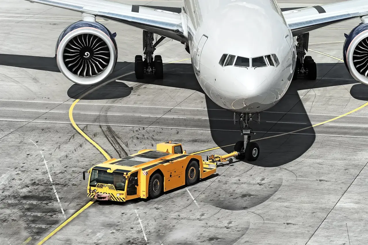
Part one: ground equipment. An FMM650 tracker from the Teltonika professional range goes on the apron vehicles and plant (for some vehicles an FMM640 from the same family will do). This is a terminal for demanding projects: a great deal of external equipment can be connected to it, and one device covers several jobs at once.
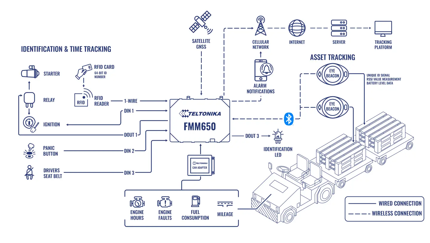
The FMM650 reads FMS CAN bus data over the SAE J1939 protocol and the J1708 bus, supports Bluetooth and comes with a set of ready-made scenarios. That is why it works with both diesel and electric equipment. Along with GNSS coordinates, the tracker sends the vehicle's parameters to the server.
What those parameters are. The position of a tug or an apron bus, fuel consumption and fuel level, mileage and speed, engine fault codes, the state of the seat belts and lights, speeding, extended idling, crash indications, geofences. For electric equipment, data about running time and idle periods.
What this gives you on the apron. The dispatcher sees all the equipment on a map and knows which tug is free nearest to the stand of an arriving aircraft. Speeding on the apron, with aircraft and people close by, is recorded at once. Extended idling of diesel equipment shows up in the report. The workshop receives fault codes and services vehicles according to actual hours rather than the calendar.
Part two: objects and people inside buildings. Here Bluetooth Low Energy beacons do the work — small radio transmitters, each of which continuously broadcasts its own identifier. Beacons are attached to whatever needs finding: trolleys, wheelchairs, expensive tools, containers, staff personal transporters. A beacon can be issued to a member of staff too.
How the network is arranged. FMM130 trackers from the advanced range are mounted permanently on ceilings or high on walls: in terminals, baggage halls, corridors, on staircases, in hangars and in car parks. They act as gateways: they hear the beacons nearby and report to the server which beacon is next to which gateway. That is how a map of what is where inside a building is built up.
What the network can do. One Teltonika tracker sees up to 100 beacons at the same time. A beacon runs on a single battery for between 2 and 10 years depending on the model. Signal strength and transmission interval are configured for the particular space, so the arrangement suits buildings of any shape and size.
What this gives you. The special assistance team quickly finds a free wheelchair. Technicians in a hangar do not spend half an hour looking for an expensive tool. You can see which trolleys have gone outside the permitted zone. The head of security sees where his teams are now and can coordinate contractors.
Part three: who is at the wheel and for how long. Drivers and operators are identified over the 1-Wire bus. A 1-Wire RFID reader connected to the FMM650 is mounted on the dashboard. Every member of staff has a contactless RFID card with a unique 64-bit number written at the factory. By presenting the card at the start of work, the driver logs on to the vehicle and the tracker records an exact date and time stamp. A Teltonika EYE Beacon can be used instead of a card.
What the HR department gets. The exact working time of every driver and operator on every vehicle. Together with third-party software, this data can be used to calculate meal breaks, overtime, idle time, travel time to a site, holidays and sick leave, allowances and expenses automatically. Arguments about who worked the night on a tug are settled with an export from the system.
One episode from a shift. A flight lands twenty minutes early. The shift supervisor opens the map and sees that the nearest free tug is standing by the neighbouring sector and the steps are by the hangar. He calls both drivers on the radio and follows the equipment towards the stand through the system. At the same time the special assistance team locates two free wheelchairs in the arrivals area from their beacons. Everything is ready by the time the doors open.
Electric equipment. For electric tugs, loaders and transporters on lithium batteries, the tracker shows how much the machine actually worked during a shift, how long it stood and when it was put on charge. That helps establish whether the electric fleet is sufficient for the peak hours, or whether some machines stand idle while others are worked into the ground. If the equipment reports battery data over CAN, that can be shown in the reports too.
Geofences on the airfield. The apron is divided into zones: aircraft stands, service roads, restricted areas, equipment parking places. Each zone has its own rules — the permitted speed, who may drive into it, how long equipment may stay there. A vehicle without clearance entering the area by the runway, or speeding next to an aircraft stand, reaches the duty officer as a notification immediately.
Which reports are the most useful. The utilisation of each piece of equipment by hour and by shift, so as to know how many tugs and buses are really needed at the peak. Idling of diesel vehicles and the fuel consumption that goes with it. Speeding offences on the apron, attached to a driver by his RFID card. Engine hours for planned maintenance. Movements of trolleys and tools between zones, to track down losses.
Matching equipment to flights. In the basic arrangement the system does not know the flight schedule: the dispatcher himself picks the nearest free vehicle from the map. An automatic prompt telling you which tug to send to which aircraft requires integration with the airport management system through an API, and that is a separate project.
Pilot criteria. The pilot counts as a success when it is clear what proportion of the equipment actually reports data over CAN, whether the track on the apron is smooth, whether the gateways find beacons in every mapped zone of the terminal, whether the RFID cards attach drivers to vehicles correctly, and how long a notification about an offence takes to reach the duty officer.
How the rollout goes. First the fleet is surveyed: what equipment there is, which vehicles have an accessible CAN bus, where analogue sensors are needed. In parallel the buildings are mapped out for the network of beacon gateways. Then the equipment is fitted to a pilot group of vehicles and one terminal zone, the data and reports are checked, and only after that is the system extended to the whole airport. That order of work means apron operations do not have to stop, and bottlenecks are found in advance.
What you get
All apron equipment on one map
The dispatcher sees where each tug, set of steps and bus is, which are free and which are nearer to the stand required.
Items in buildings are found in minutes
Bluetooth beacons and tracker gateways show where the trolleys, wheelchairs and expensive tools are, even where GPS does not work.
Exact working time without timesheets
RFID cards on the 1-Wire bus record who worked on a vehicle and when, and the data is available from a computer, a tablet or a smartphone.
Maintenance by actual hours
CAN data, fault codes and engine hours make it possible to plan servicing and reduce unexpected downtime.
More discipline on the apron
Speeding, idling and geofence breaches are visible at once, and together with an incentive scheme this changes drivers' habits.
An arrangement to suit any building
Beacon power and interval are configured for the particular terminal or hangar, and the gateway network can be extended as required.
Why this solution
An airport needs not a single tracker but a set of devices that work as one system. Teltonika has all of it in one range: professional FMM650 and FMM640 trackers with CAN reading for heavy equipment and plant, compact FMM130 units suited to the role of fixed gateways, Bluetooth beacons, 1-Wire RFID readers and EYE Beacon for identification. Devices from one manufacturer are simpler to configure, update and maintain.
The FMM650 is good because it works with both the FMS standard (SAE J1939) and J1708, which covers most lorry and bus equipment. A wide set of inputs and outputs lets you connect sensors, readers and other equipment to it without additional units.
Teltonika data is transmitted over open protocols and integrates easily with airport management platforms and working time systems. Tracker firmware and settings are updated remotely, so equipment does not have to be gathered in one place in order to change a configuration — which matters on an apron that works without a break.
Beacons need no mains power and no wiring. They are fixed to a trolley or a tool in a minute, and the battery lasts for years. That makes it realistic to keep track of small but expensive property: putting a tracker on every trolley would previously have been far too expensive and complicated.
The limitations are worth bearing in mind. Positioning inside buildings needs a well-thought-out gateway network: accuracy depends on how many there are and where they are placed, and this is not navigation accurate to a metre but an understanding of which zone an item is in. On an airfield all installation work goes through clearance with the security service and takes place in allotted windows, so rollout timescales are set with room to spare. Some older series of plant may not report data over CAN, and analogue inputs and sensors are used for those.
How this works in Azerbaijan. The largest site is Heydar Aliyev International Airport in Baku, with a cargo terminal and a large fleet of apron equipment. Beyond it there are regional airports in Ganja, Nakhchivan, Lankaran, Gabala and Zagatala, while in Karabakh and East Zangezur airports have opened at Fizuli, Zangilan and Lachin. Their fleets are smaller but the tasks are the same: see the equipment, keep records of drivers' work and avoid losing kit. In summer the apron tarmac in Baku heats up so much that equipment often works at its limit, and monitoring idling and overheating over CAN comes in very handy here. In winter in Nakhchivan and Gabala de-icing vehicles and snow ploughs are added, and it matters to keep them in view. On an airfield we begin the rollout with a survey: which equipment can be connected over CAN, where gateways for the beacons are needed, how clearances with security work. SIM cards are chosen from Azercell, Bakcell or Nar according to the quality of coverage on the particular apron. GPS.az fits the trackers, beacons and RFID readers and brings all the equipment, people and items onto the Wialon platform: an apron map, equipment utilisation reports, driver time records and notifications for the dispatcher.
Related case studies
Related rollouts and equipment
Questions about the “Monitoring airport ground support equipment” scenario
Request a call
A specialist will call back and match a solution to your fleet and your task.