
Indoor positioning with EYE beacons
A Teltonika use case: how to find people, goods, tools and equipment inside buildings where GPS does not work, using Bluetooth EYE beacons and Teltonika trackers.
A Teltonika use case: how to find people, goods, tools and equipment inside buildings where GPS does not work, using Bluetooth EYE beacons and Teltonika trackers. Outdoors, any smartphone has been working out its location for years. Inside a warehouse, a shopping centre, a hospital or an airport the satellite signal weakens and bounces off the walls, and the error is sometimes larger than the building itself. Yet it is precisely inside buildings that managers spend the most time searching: where has the forklift gone, where is the pallet with the urgent order, which wing is the duty technician in now. In this use case Teltonika looks at how to close the blind spot left by GPS with EYE beacons — small Bluetooth transmitters that trackers read and pass to the server together with their own coordinates. Below are three working approaches, their strengths and the honest limitations of each.
What this scenario solves
In large buildings, managers spend a great deal of time looking for people, goods and equipment.
The GPS signal weakens indoors and scatters off roofs and walls.
The error of some GPS chips can exceed the dimensions of the building itself.
Without an accurate position inside a building there is no way to build a search, a record of movements or reports on utilisation.
In large buildings, managers spend a great deal of time looking for people, goods and equipment. The GPS signal weakens indoors and scatters off roofs and walls. The error of some GPS chips can exceed the dimensions of the building itself. Without an accurate position inside a building there is no way to build a search, a record of movements or reports on utilisation.
Where this hurts most. Warehouses and logistics centres, shopping centres and supermarkets, exhibition complexes and fairs, airports and railway stations, hospitals, concert halls and sports arenas. Everywhere the picture is the same: there are many objects, they move, and the people responsible for them search by hand and by telephone.
Satellite navigation became generally available in the late nineties and changed everything that happens in the open air. Today almost everybody has a smartphone, a watch or a tracker with GPS. But under a roof the technology runs into physics: the signal passes through concrete and metal with heavy losses, it reflects, and it makes the coordinates jump. In narrow streets between tall buildings the problem is the same.
The other side of the question is software. Even once coordinates inside a building have been obtained, they have to be shown on a floor plan, with search and filters, movement history and a convenient way of registering new assets and staff. Without that the data turns into a stream of figures nobody looks at.
What Teltonika offers
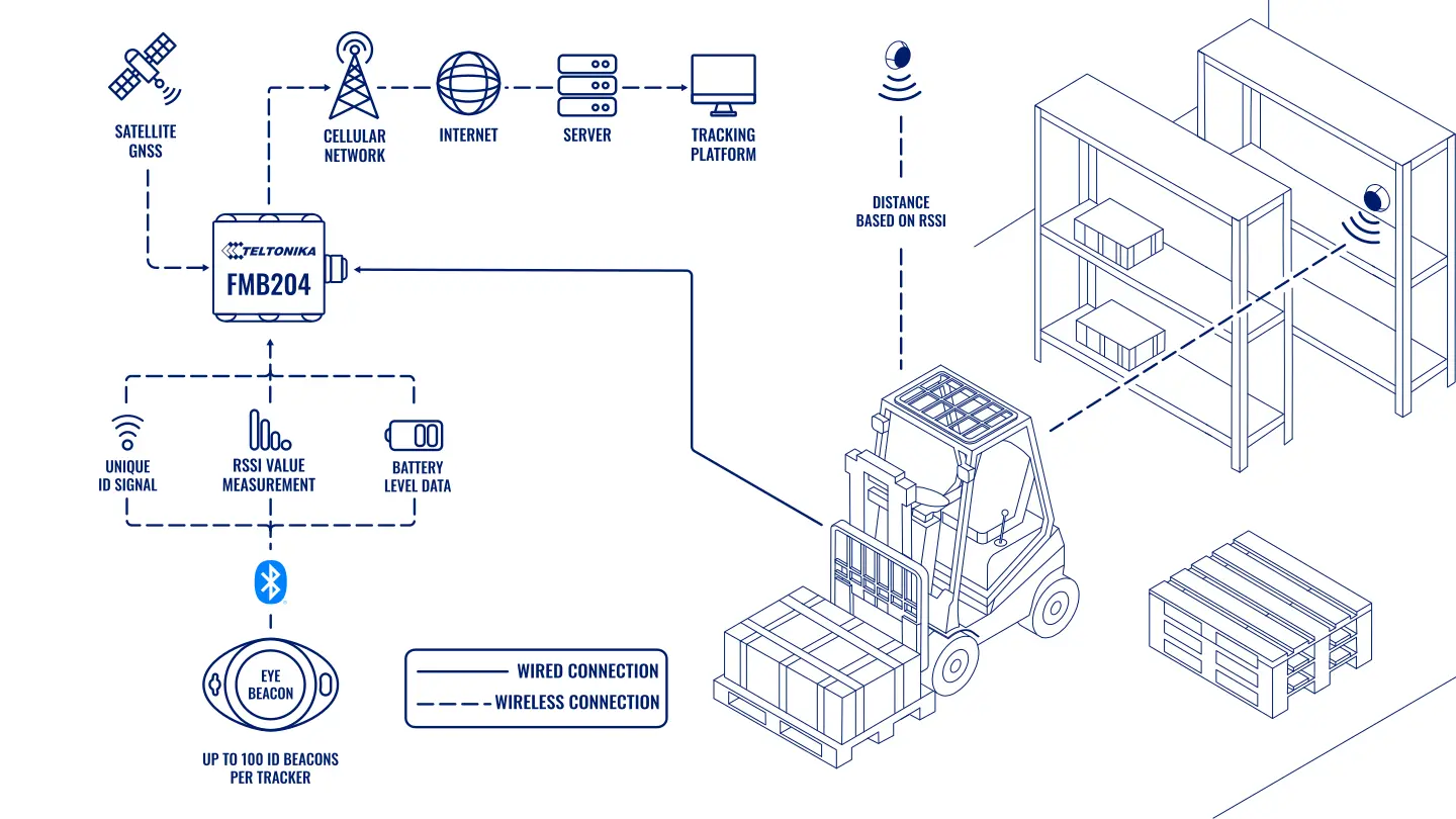
For indoor use Teltonika backs Bluetooth Low Energy: EYE beacons broadcast their identifier, Teltonika trackers read it and send it to the server together with GNSS coordinates and the time.
Installation and setup
Fitting the device and configuring it for the fleet scenario at hand.
Data transfer
The device collects data and sends it to the monitoring platform; how often depends on the model and its settings.
Analysis and control
The person in charge gets reports and alerts and looks into what stands out.

Why Bluetooth in particular. There are plenty of options for positioning inside buildings: Wi-Fi, magnetic field, NFC, ultra-wideband UWB, UHF RFID radio frequency tags. They differ in price, accuracy, compatibility and how hard they are to deploy. UWB is more accurate but needs expensive infrastructure. RFID is good on a warehouse gate but poor for continuous tracking. Bluetooth LE sits in the middle: the beacons are cheap, run for years on a battery, do not depend on the cellular network, and are easy to place and to fit into a system already running on Teltonika trackers.
What EYE beacons can do. Each has its own identifier, and the signal strength and transmission interval are set to suit the task. Depending on the model, a beacon runs from 2 to 10 years on one battery. Teltonika quotes a range of up to 500 m in open space; in a building with walls and racking it is noticeably less, and that has to be allowed for when placing them. One Teltonika tracker can see up to 100 beacons at the same time.
Approach 1. A beacon on the object, a tracker nearby. Beacons are attached to whatever has to be found: pallets, containers, tools, trolleys, staff badges. Trackers read the beacons near them and send them to the server. The software works out the position of each beacon from which tracker sees it and how strong the signal is.
Approach 2. A beacon on the wall, a tracker on the vehicle. Beacons are fixed at particular points in the building and used as location markers: gate 3, the goods-in area, the wash bay, bay 12. When a forklift or a vehicle with a tracker enters a beacon’s area, the system knows where it is. Outdoors the same vehicle is tracked by GNSS, indoors by the beacons, and there is no break in the history of the journey.
Approach 3. A tracker as a fixed gateway. A tracker is fixed to a wall, a ceiling or a rack, connected to power and used as a collection point: it receives the signals of moving beacons and passes them to the cellular network. For a GPS tracker that is an unusual role, but it has turned out to be in demand — there is no need to install separate gateways and run internet to them.
An example in a warehouse. A storeman needs the pallet with an urgent order. Instead of walking the aisles he opens the interface and sees that the pallet’s tag was last read by the gateway at the dispatch area twenty minutes ago. At the same time the shift supervisor sees that two forklifts have not left the charging area since the morning: either they are standing idle or they have broken down, and that is a reason to go over.
What is visible in the software. Dedicated software shows the beacons on a plan of the site, with search and filters, movement profiles, history by time, registration of new objects and staff, and monitoring dashboards. For moving equipment the data can be kept on the familiar telematics platform alongside the journeys outside.
What can be tracked. Goods and containers, staff, visitors, mobile tools, forklifts and vehicles, and also the movement routes of people and objects themselves, so as to see where congestion and unnecessary mileage build up.
How the site is checked before launch. A walk round with the EYE app shows where beacons are heard reliably and where the signal is killed by racking, cold stores and concrete floors. The results decide how many gateway trackers are needed, where they will take their power from, and whether there is enough cellular coverage at those points to transmit the data. The acceptance criterion is simple: a beacon left in a known area shows up in that area several times in a row, and when it is moved to the next one the system reflects the change.
Last detection and battery. For every beacon the software keeps the time and the place where a tracker or gateway last heard it. If nobody has seen a tag for a long time, the last known area stays on screen with a timestamp: that is a reason to go and check the object, and the beacon’s battery and mounting along with it.
What you get
It is clear where everything is
Goods, assets and staff are tracked inside a building the same way vehicles are outside, and a search takes minutes instead of a walk round.
Better service for visitors
In shopping centres, hospitals and railway stations beacons help to build navigation and location prompts for smartphones.
Fewer losses and thefts
Valuable assets with tags do not disappear without trace, and the movement history shows where and when an object went missing.
Safety of people
In an incident or an evacuation it is clear who is in which part of the building, and hazardous areas can be monitored separately.
Tuned to the site
The signal strength and the interval of the beacons are matched to the floor area and the layout, from a small warehouse to an exhibition complex.
Quick fitting and replacement
Wireless beacons go up without cables, and a damaged or stolen beacon is replaced in minutes.
Why this solution
Teltonika’s strength in this scenario is one stack for outdoors and indoors. The same trackers that sit on the vehicles read EYE beacons, so there is no need to build one system for the warehouse and another for the vehicles. The beacons are configured with the same tools as the trackers, and a tracker can be put into the role of a fixed gateway.
Honestly about accuracy. Bluetooth positioning gives an area, not a point: it is clear which gate or which aisle an object is in, but not which shelf. If accuracy to tens of centimetres is needed, UWB is the direction to look, but that is a different budget. Metal racking and concrete floors kill the signal, so the placement of beacons and gateways is verified by measurements on site. The building plan will suggest where to start, but the real picture comes only from a walk round with a phone and the EYE app, which sees the beacons and their signal level.
And about the software. Showing things on a floor plan often calls for specialised software. A telematics platform shows equipment and events very well, but a full warehouse map with shelves is a separate task, worth discussing before any purchase.
How this works in Azerbaijan. The scenario suits logistics centres in Absheron and in the area of the port of Alat, distributors’ warehouses in Baku and Sumgait, shopping centres and hypermarkets, large hospitals, the Baku Expo Center exhibition complex and sports arenas, and also the industrial sites of oil and gas contractors where equipment and tools are moved between workshops. Most often the start is made with forklifts and expensive tools: that is where the effect shows soonest. When rolling it out, allow for the summer heat: beacons outdoors and in unheated hangars at up to +40 °C are placed in the shade, so as not to shorten the battery life. GPS.az, as a Teltonika GOLD partner in Azerbaijan, surveys the site, places the beacons and the trackers, and brings the equipment and beacon data onto the Wialon platform, where the dispatcher or the warehouse manager sees it.
Related case studies
Related rollouts and equipment

Questions about the “Indoor positioning with EYE beacons” scenario
Request a call
A specialist will call back and match a solution to your fleet and your task.